Lake of Fire
Geometry and Tactics in the Persian Gulf

Wednesday 25 March 2026
The 31st Marine Expeditionary Unit (MEU) is about to chop into the CENTCOM Area of Responsibility, while the 11th MEU is deploying from the United States in that direction. At the same time, open-source reporting shows a steady flow of C-17 flights moving forces forward. I am not a disinterested observer. I have spent time on MEUs across the range of contingencies they are designed for, and that experience shapes how I look at this. Set aside, for the moment, the question of Congressional authorization—it is worth understanding the environment these forces are entering.
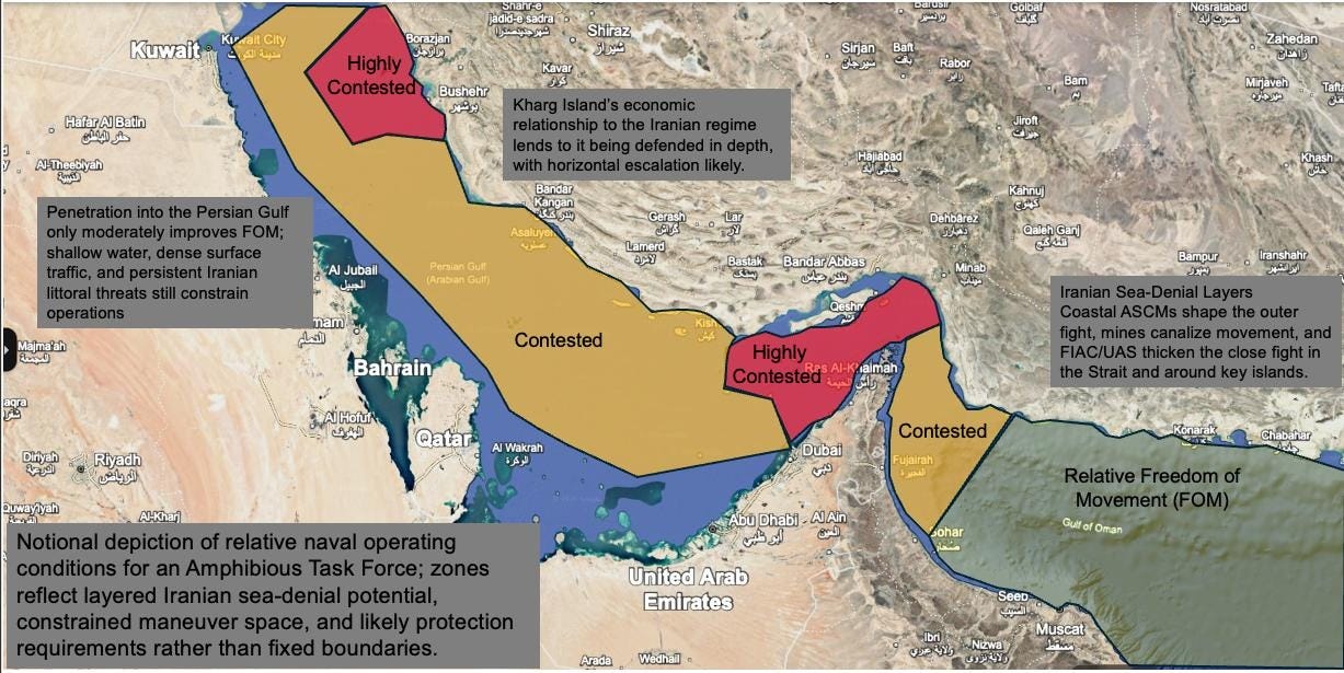
Start with the map. I created a simple graphic while dwelling on this. The Persian Gulf is not open ocean. It is a shallow, constrained basin with dense commercial traffic and constant proximity to the Iranian coastline. The Strait of Hormuz is not just a chokepoint; it is a narrow transit route where movement is predictable and options are limited. This is geometry before it is tactics, and geometry does not care.
Inside this space, freedom of movement is already restricted before a shot is fired. Traffic compresses maneuver, routes are canalized, and timelines become more predictable the closer forces operate to key terrain along the Iranian coast and around the Strait. Iran does not need to control this environment in a traditional naval sense or win a decisive engagement at sea. It only needs to make movement uncertain enough that it slows, fragments, or stops. That is a different kind of control, but it is real.
For forces operating inside the Gulf, presence is not neutral. A ship, or a MEU, is not simply forward—it is operating inside a constrained system where movement is predictable and sustainment is exposed. Over time, that matters more than the opening move. Options narrow, logistics become more complex, and risk accumulates in ways that are not easily reversed once forces are committed.
The forces do offer options that airpower has not; they can raid ashore to reduce defenses or otherwise shape the campaign. (Raid: deliberate attack with a planned withdrawal). Or they can seize that terrain. The inherent challenge is seizing it may not be that difficult. Holding that will be the real challenge.
It is tempting to look at the map and assume that seizing key terrain—Abu Musa, the Tunbs, Qeshm—would solve the problem of naval vulnerability and open the SoH for shipping. It would not. At best, that creates localized control and a potential bargaining position. It does not make the Strait “open” in any meaningful sense, because the conditions that make movement uncertain still exist.
Kharg Island is a different case entirely. That is not about controlling the Strait. That is about striking Iran’s economic center of gravity—and accepting the escalation that comes with it.
Before we put sailors, Marines, and soldiers into a constrained battlespace like this, it is worth asking what the end state is that justifies that risk—because once they are committed, we may not be the ones who get to decide how this ends.